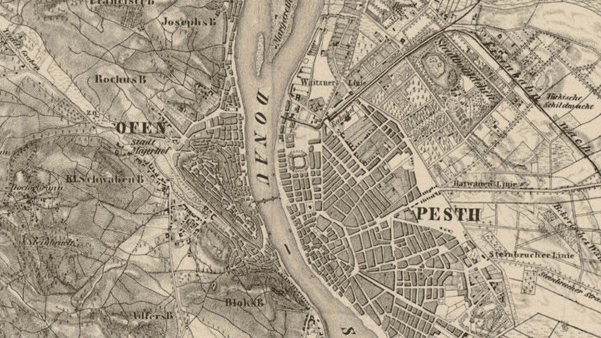
While even many of those who do not live in Budapest have some idea of the most important districts of our capital, and although connecting their numbers with the corresponding names sometimes may puzzle even the locals, they can usually associate at least a few special locations or thoughts with each of the city’s districts. But the story of the individual districts is a brief summary of the past centuries not only from the point of view of their names: if we look at them on the map, we can immediately see that the history of their establishment and development is also the history of the expansion of Budapest and the changes of its urban agglomeration.
When the capital was established in 1873 with the union of Pest, Buda and Óbuda, it originally had ten districts, but over time, partly due to district rearrangements and partly to the expansion of city’s boundaries, this number has since grown to twenty-three. The number of the parts of town (such as Albertfalva, Lágymányos, Csillebérc, Kelenföld, or Corvin-negyed) is even larger than that, as we can distinguish about 203 of them within the districts—and their number is still increasing. For example, in 2007, a new quarter called Palotanegyed (Palace Quarter) came into existence. It is worth mentioning a few exceptions as well, such as Margaret Island, which does not belong to any district but is directly managed by the Municipality of Budapest (earlier, it was part of the 13th district).
The districts have their own municipalities and competencies and, in many cases, even their own coat of arms, flags, and twin settlements. They coordinate and cooperate with each other and report on it to the central government in the General Assembly of Budapest—thus, the districts practically function as ‘cities within a city’. Although their territory and boundaries have changed over time, the names of the original districts were largely the same as today; so the 1st district (with the parts of town called Várnegyed (Castle District), Tabán, and Krisztinaváros), the 2nd district (Víziváros), the 3rd district (Óbuda), or the 10th district (Kőbánya) already existed at the time of the unification of Budapest.
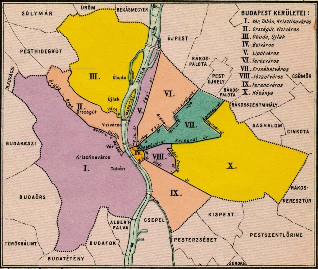
The first major expansion goes back to 1930: then, the number of the capital’s districts rose to fourteen, while the total population also increased significantly with the annexation of the surrounding small-sized but populous areas. The 1st district, which previously covered almost the entire area of Buda, was divided in the same year, by which several new districts were created and some other outlying areas also came within the jurisdiction of the capital, such as the Budakeszi Forest or the Port of Csepel.
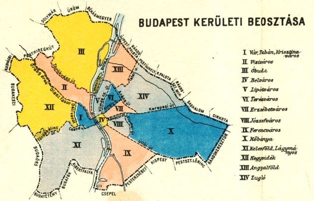
From then on, several districts and working-class suburbs considered traditional today gradually emerged, such as Zugló (the 14th district) or Angyalföld (the 13th district), and it was at that time that Belváros (Central Budapest, the 5th district), that is, the historical centre of Pest, became surrounded by Pest districts such as Lipótváros (5th district), Terézváros (6th district), Erzsébetváros (7th district) and Józsefváros (8th district), which were established by German settlers after the Turkish occupation and the demolition of the city walls. Together with Ferencváros (9th district), what these quarters on the Pest side have in common is that they all bear the name of members of the Habsburg dynasty, while some sections of the Grand Boulevard are also distinguished by the names of their corresponding districts (József Boulevard in the 8th district, Erzsébet Boulevard in the 7th district, and so on.)
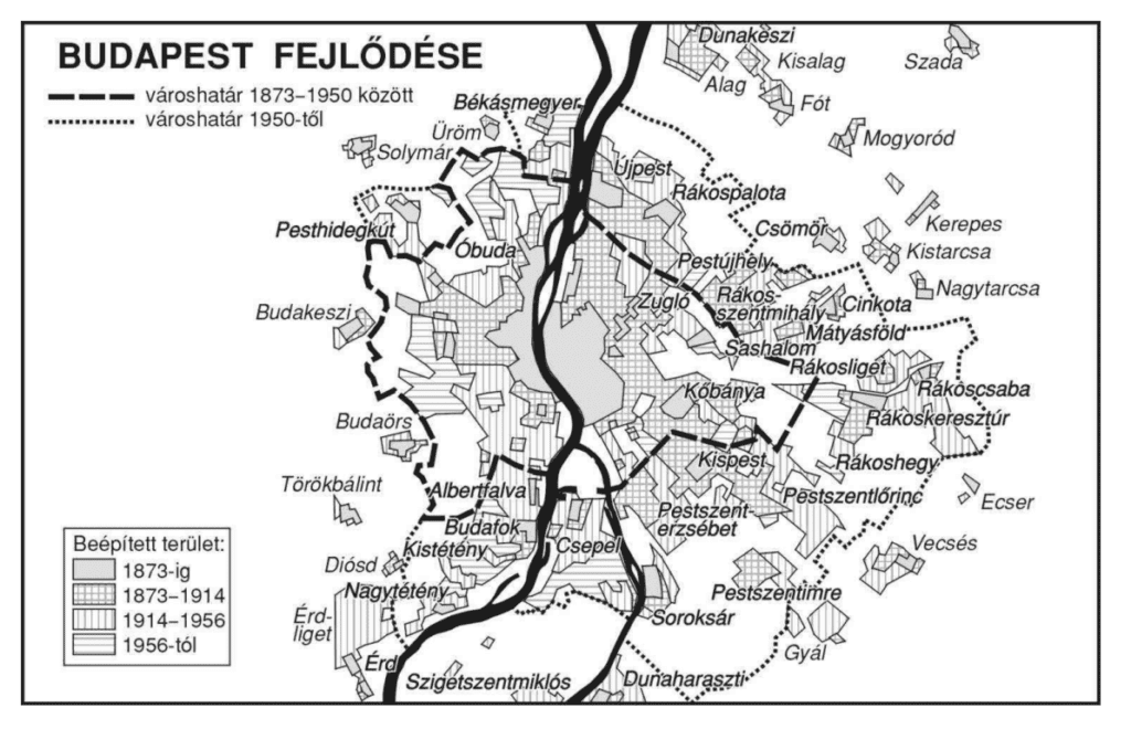
The next milestone in the history of the districts of Budapest was 1950, when the so-called ‘Greater Budapest’ emerged by the merging of some of the surrounding settlements (Cinkota, Mátyásföld, Sashalom, Békásmegyer, or Pesthidegkút) into the capital—from this point on, the size of the capital reached its current form. The Rákos Stream (which flows along the settlements of Rákoscsaba, Rákospalota, and Rákosszentmihály) also came within the jurisdiction of Budapest in the same year, however, some changes have taken place since then. For example, in 1994 Soroksár was separated from Pesterzsébet, and thus the city’s smallest district, the 23rd was created.
In addition, the districts of Central Budapest and Lipótváros have also merged, and the 4th district became the newly created Újpest, while the 11th became Újbuda from then on, which is the district with the largest number of residents in the Hungarian capital. In terms of population density, Erzsébetváros (7th district) is in first place, while Rákosmente (17th district) is the district with the largest area. Another fun fact is that the population of Budapest reached its peak in 1980, when the capital had more than two million inhabitants, compared to today’s approximately only 1.7 million people.
Click here to read the original article